Walternienburg: Difference between revisions
Jump to navigation
Jump to search
Knorrepoes (talk | contribs) m (Text replace - "'''Origin/meaning :'''<br/>" to "====Origin/meaning====") |
Knorrepoes (talk | contribs) m (Text replace - "|width="15%"|50 px|right |}" to "|width="15%"|50 px|right |}<seo title="Wappen, Gemeindewappen" />") |
||
| Line 3: | Line 3: | ||
|width="70%" align="center" |'''Heraldry of the World<br/>Civic heraldry of [[Germany]] - [[Deutsche Wappen|Deutsche Wappen (Gemeindewappen/Kreiswappen)]]''' | |width="70%" align="center" |'''Heraldry of the World<br/>Civic heraldry of [[Germany]] - [[Deutsche Wappen|Deutsche Wappen (Gemeindewappen/Kreiswappen)]]''' | ||
|width="15%"|[[File:Germany.jpg|50 px|right]] | |width="15%"|[[File:Germany.jpg|50 px|right]] | ||
|} | |}<seo title="Wappen, Gemeindewappen" /> | ||
Revision as of 18:47, 5 November 2012
 |
Heraldry of the World Civic heraldry of Germany - Deutsche Wappen (Gemeindewappen/Kreiswappen) |
|
WALTERNIENBURG
State : Sachsen-Anhalt
District (Kreis) : Anhalt-Bitterfeld (until 2007 Anhalt-Zerbst)
Verwaltungsgemeinschaft : Verwaltungsgemeinschaft Elbe-Ehle-Nuthe
Incorporated into : 2010 Zerbst

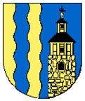
Official blazon
Gespalten durch Wellenschnitt Gold über Blau; vorn ein blauer Wellenpfahl, hinten ein dreistufiger goldener Turm mit schwarzen Dächern, goldener Kugel und schwarzer Wetterfahne.
Origin/meaning
The arms were officially granted on June 2, 1995.
The arms symbolise the position of the village near the Nuthe and Elbe rivers by the wavy division line and the pale. The tower is the local historical (over 1000 years old) watchtower, a typical symbol for the village. The colours refer to water and agriculture.
Literature : Image from Wikipedia