Oostkerke (Damme): Difference between revisions
Knorrepoes (talk | contribs) m (Text replacement - " Vrije van Brugge " to " Vrije van Brugge ") Tags: Mobile edit Mobile web edit |
Knorrepoes (talk | contribs) |
||
| (9 intermediate revisions by the same user not shown) | |||
| Line 1: | Line 1: | ||
{{ | {| class="wikitable" | ||
|- style="vertical-align:top;" | |||
|[[File:oostkerb.jpg|center|alt=Wapen van {{PAGENAME}}/Arms (crest) of {{PAGENAME}}]] | |||
| | |||
<center>''' {{uc:Oostkerke}} '''</center><br> | |||
'''Country''' : Belgium [[File:Belgium.jpg|60 px|right]]<br><br><br> | |||
'''Province''' : <br>[[West-Vlaanderen]][[File:westvlaanderen.jpg|60 px|right]]<br><br><br> | |||
'''Incorporated into:''' | |||
* 1976 [[Damme]] | |||
<br> | |||
{{#display_map:51.2773,3.2952|width=250|height=250|zoom=7}} | |||
|} | |||
''' | {| class="wikitable" | ||
|+Official blazon | |||
|- | |||
|'''French''' | |||
| De gueules, à trois croissants d'or. | |||
|- | |||
|'''English''' | |||
| blazon wanted | |||
|} | |||
===Origin/meaning=== | ===Origin/meaning=== | ||
| Line 15: | Line 27: | ||
The arms are derived from the arms of the Lords of Oostkerke. The arms are first mentioned in the Gelre roll of arms from the late 14<sup>th</sup> century. They also appear as arms for the town on the 16<sup>th</sup> century map of the [[Vrije van Brugge]] area, see below. | The arms are derived from the arms of the Lords of Oostkerke. The arms are first mentioned in the Gelre roll of arms from the late 14<sup>th</sup> century. They also appear as arms for the town on the 16<sup>th</sup> century map of the [[Vrije van Brugge]] area, see below. | ||
The same arms are used by the nearby village of [[Hoeke]], but the relation with the Lords of Oostkerke is not clear. | |||
The same arms are used by the village of [[Hoeke]], but the relation with the Lords of Oostkerke is not clear. | |||
===Image gallery=== | |||
| | <gallery widths=250px heights=200px perrow=0> | ||
File:oostkerke.map.jpg|alt=Wapen van Oostkerke/Arms (crest) of Oostkerke|The arms on the map of Pieter Pourbus (1571, Groeningemuseum, Brugge) | |||
File:Oostkerke1543.jpg|alt=Wapen van Oostkerke/Arms (crest) of Oostkerk|The arms in a 16th century manuscript | |||
File:Oostkerke1619.jpg|alt=Wapen van Oostkerke/Arms (crest) of Oostkerke|The arms in 1619 | |||
File:oostkerke.hagbe.jpg|alt=Wapen van Oostkerke/Arms (crest) of Oostkerke|The arms in the [[Koffie Hag Belgium|Koffie Hag/Café Hag albums]] +/- 1930 | |||
File:oostkerke2.jpg|alt=Wapen van Oostkerke/Arms (crest) of Oostkerke|The arms in the village (2017) | |||
</gallery> | |||
==Monnikerede== | ==Monnikerede== | ||
| Line 30: | Line 42: | ||
The city of Monnikerede developed as a small harbour city on the Zwin in the 13th century. Due to silting, the harbour disappeared and the town was merged with Hoeke and Damme to one unit in 1594 (see [[Damme]]). The city was situated in the later municipality of Oostkerke, but no remains are visible. | The city of Monnikerede developed as a small harbour city on the Zwin in the 13th century. Due to silting, the harbour disappeared and the town was merged with Hoeke and Damme to one unit in 1594 (see [[Damme]]). The city was situated in the later municipality of Oostkerke, but no remains are visible. | ||
===Image gallery=== | |||
<gallery widths=250px heights=200px perrow=0> | |||
File:monnikeredez1.jpg|alt=Zegel van Monnikerede/Seal of Monnikerede|The seal of Monnikerede from the late 13th century (Ewe, 1972) | |||
| | File:monnikeredez2.jpg|alt=Zegel van Monnikerede/Seal of Monnikerede|The seal of Monnikerede from 1300 (Ewe, 1072) | ||
File:Monnikerede1558.jpg|alt=Wapen van Monnikerede/Arms (crest) of Monnikerede|The arms in a manuscript from 1558 | |||
File:monnikerede.map.jpg|alt=Wapen van Monnikerede/Arms (crest) of Monnikerede|The arms on the map of Pieter Pourbus (1571, Groeningemuseum, Brugge) | |||
</gallery> | |||
[[Civic Heraldry Literature - Belgium|'''Literature''']]: Servais, 1955 | |||
{{be}} | |||
{{media}} | {{media}} | ||
[[Category:Belgian Municipal Arms O]] | [[Category:Belgian Municipal Arms O]] | ||
[[Category:West-Vlaanderen]] | [[Category:West-Vlaanderen]] | ||
[[Category:Granted 1845]] | [[Category:Granted 1845]] | ||
Latest revision as of 14:26, 26 February 2024
 |
Country : Belgium  Province : West-Vlaanderen Incorporated into:
|
| French | De gueules, à trois croissants d'or. |
| English | blazon wanted |
Origin/meaning
The arms were granted on February 25, 1845.
The arms are derived from the arms of the Lords of Oostkerke. The arms are first mentioned in the Gelre roll of arms from the late 14th century. They also appear as arms for the town on the 16th century map of the Vrije van Brugge area, see below.
The same arms are used by the nearby village of Hoeke, but the relation with the Lords of Oostkerke is not clear.
Image gallery
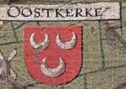
The arms on the map of Pieter Pourbus (1571, Groeningemuseum, Brugge)
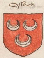
The arms in a 16th century manuscript
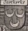
The arms in 1619
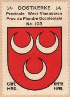
The arms in the Koffie Hag/Café Hag albums +/- 1930
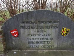
The arms in the village (2017)


Monnikerede
The city of Monnikerede developed as a small harbour city on the Zwin in the 13th century. Due to silting, the harbour disappeared and the town was merged with Hoeke and Damme to one unit in 1594 (see Damme). The city was situated in the later municipality of Oostkerke, but no remains are visible.
Image gallery
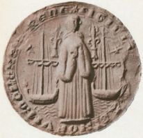
The seal of Monnikerede from the late 13th century (Ewe, 1972)
The seal of Monnikerede from 1300 (Ewe, 1072)
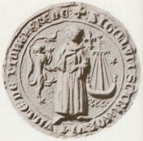
The arms in a manuscript from 1558
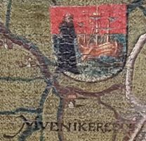
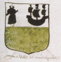
The arms on the map of Pieter Pourbus (1571, Groeningemuseum, Brugge)


Literature: Servais, 1955
Belgium heraldry portal
This page is part of the |
 |
|
Civic heraldry:
|
Other heraldry: |
Contact and Support


Partners:


Your logo here ?
Contact us
© since 1995, Heraldry of the World, Ralf Hartemink 
Index of the site