Retzwiller: Difference between revisions
Jump to navigation
Jump to search
Knorrepoes (talk | contribs) (Created page with '{|width="100%" style="color:black; background-color:#ffffcc;" |width="15%"|50 px|left |width="70%" align="center" |'''Heraldry of the World<br/>Civic heraldry…') |
Knorrepoes (talk | contribs) m (Text replace - "|width="15%"|50 px|right |}" to "|width="15%"|50 px|right |}<seo title="Armorial de France, Armoires, Blason" />") |
||
| Line 3: | Line 3: | ||
|width="70%" align="center" |'''Heraldry of the World<br/>Civic heraldry of [[France]] - [[Armorial de France]]''' | |width="70%" align="center" |'''Heraldry of the World<br/>Civic heraldry of [[France]] - [[Armorial de France]]''' | ||
|width="15%"|[[File:France.jpg|50 px|right]] | |width="15%"|[[File:France.jpg|50 px|right]] | ||
|} | |}<seo title="Armorial de France, Armoires, Blason" /> | ||
'''RETZWILLER''' | '''RETZWILLER''' | ||
Revision as of 11:06, 6 November 2012
 |
Heraldry of the World Civic heraldry of France - Armorial de France |
|
RETZWILLER
Département : Haut-Rhin

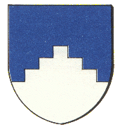
Origin/meaning
The arms shows a point, pictured as stairs. These represent the fact that the Canal du Rhône au Rhin, which canal passes through Retzwiller, attains its highest altitude in Retzwiller (about 348 m) on its way from Mulhouse to Sochaux. From the Rhine up to Retzwiller the reaches ("biefs" in French, in other words the part of the canal between two locks) are ascending up to Retzwiller where the highest "reach" is located. From this highest "reach" in Retzwiller the canal goes on descending in direction South (towards Sochaux) until the Rhône.
Literature : Image taken from http://cdhf.telmat-net.fr/villages, with permission; background from Francis With